Òbrôzk:Muizz Street - Egypt.jpg

Miara pòdzérkù – 800 × 563 pikslów. Jinszy rozdzélnotë: 320 × 225 pikslów | 640 × 451 pikslów | 1024 × 721 pikslów | 1280 × 901 pikslów | 2560 × 1802 pikslów | 5682 × 4000 pikslów.
Pierwòtny lopk (5682 × 4000 pikslów, miara lopka: 18,06 MB, ôrt MIME: image/jpeg)
Òpisënk
| Òpisënk |
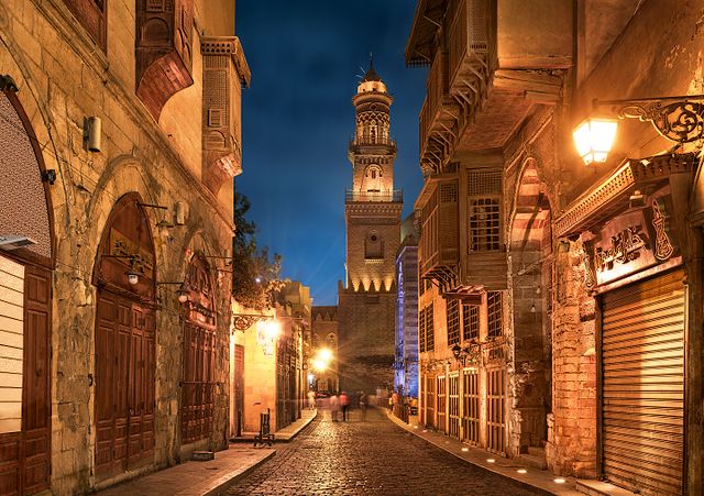
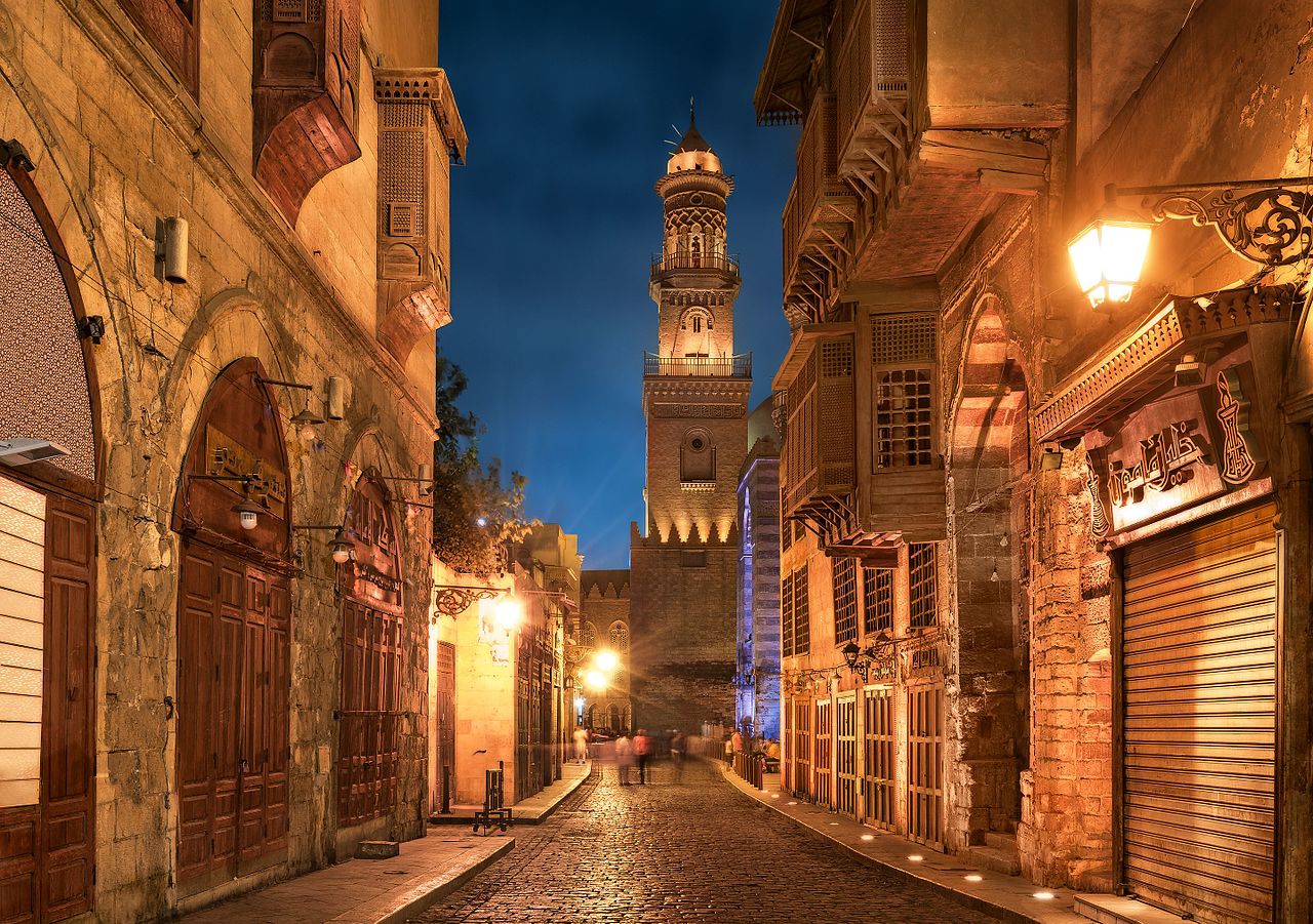
English: Old cairo between history and future.jpg Essam Azzam St. (Shariʻa al-Muizz li-Deen Illah) (30°02′ 48" N 31°15′ 36"E) in Islamic Cairo, Egypt is one of the oldest streets in Cairo, approximately one kilometer long. A United Nations study found it to have the greatest concentration of medieval architectural treasures in the Islamic world.[1] The street (shariʻa in Arabic) is named for Al-Muʿizz li-Deen Illah, the fourth caliph of the Fatimid dynasty. It stretches from Bab Al-Futuh in the north to Bab Zuweila in the south. Starting in 1997,[2][3] the national government carried out extensive renovations to the historical buildings, modern buildings, paving, and sewerage to turn the street into an "open-air museum". On April 24, 2008, Al-Muizz Street was rededicated as a pedestrian only zone between 8:00 am and 11:00 pm; cargo traffic will be allowed outside of these hours.[4]
The northern part of the street extends from the Al-Hakim Mosque in the north to the Spice Market at Al-Azhar Street and includes the antiques markets section, Al-Aqmar Mosque (one of the few extant Fatimid mosques), the Qalawun complex, and several well preserved medieval mansions and palaces. |
| Datum | |
| Zdrój | Swòjô robòta |
| Aùtor | Mohammed Moussa |
| Pozycja fotografa | | To i inne zdjęcia na: OpenStreetMap |
|---|
Licencëjô
Ja, właściciel praw autorskich do tego dzieła, udostępniam je na poniższej licencji
Ten plik udostępniony jest na licencji Creative Commons Uznanie autorstwa – Na tych samych warunkach 4.0 Międzynarodowe.
- Mòżesz:
- dzélëc sã – kòpirowac, rozprowôdzac, ódtwarzac ùsôdztwò
- zmieniwac – ùsôdzac zanôléżné ùsôdztwa
- Na nôslédnych warunkach:
- ùznanié ùsôdztwa – Ùsôdztwò je nót nacéchòwac na ôrt òpisóny przez ùsôdzcã abò licencjodawcã.
- wedle tich sómych prawów – Jeżlë zjinaczô sã abò przekształcô ùniższi ùsôdzk, abò ùsôdzô sã jinny na jegò spòdlim, to mòże je rozkòscérzac wëszłi na nen ôrt ùsôdzk blós na równy abò zblëżony licencëji.

|
Ta fotografia została przesłana w ramach projektu Wiki Lubi Zabytki będącego częścią inicjatywy Wiki Loves Monuments 2016.
|
 |
Historëjô lopka
Klëkni na datum/czas, abë òbaczëc jak wëzdrzôł lopk w tim czasu.
| Datum/Czas | Miniatura | Miara | Brëkòwnik | Òpisënk | |
|---|---|---|---|---|---|
| aktualny | 02:13, 30 Séw 2016 | | 5682 × 4000 (18,06 MB) | M mousa 86 | User created page with UploadWizard |
Lënczi do lopka
Hewò są starnë, jaczé òdwòłëją sã do negò lopka:
Globalné wëzwëskanié lopka
Nene lopk je téż brëkòwnóny w jinnych ùdbach Wiki:
- Wëzwëskanié w ar.wikipedia.org
- Wëzwëskanié w azb.wikipedia.org
- Wëzwëskanié w bcl.wikipedia.org
- Wëzwëskanié w bs.wikipedia.org
- Wëzwëskanié w el.wikipedia.org
- Wëzwëskanié w en.wikipedia.org
- Wëzwëskanié w et.wikipedia.org
- Wëzwëskanié w eu.wikipedia.org
- Wëzwëskanié w fa.wikipedia.org
- Wëzwëskanié w hy.wikipedia.org
- Wëzwëskanié w id.wikipedia.org
- Wëzwëskanié w inh.wikipedia.org
- Wëzwëskanié w ja.wikipedia.org
- Wëzwëskanié w lt.wikipedia.org
- Wëzwëskanié w mai.wikipedia.org
- Wëzwëskanié w ne.wikipedia.org
- Wëzwëskanié w pnb.wikipedia.org
- Wëzwëskanié w ps.wikipedia.org
- Wëzwëskanié w pt.wikipedia.org
- Wëzwëskanié w ru.wikipedia.org
- Wëzwëskanié w sat.wikipedia.org
- Wëzwëskanié w sd.wikipedia.org
- Wëzwëskanié w simple.wikipedia.org
- Wëzwëskanié w sr.wikipedia.org
- Wëzwëskanié w te.wikipedia.org
- Wëzwëskanié w th.wikipedia.org
- Wëzwëskanié w tr.wikipedia.org
- Wëzwëskanié w uk.wikipedia.org
- Wëzwëskanié w ur.wikipedia.org
- Wëzwëskanié w uz.wikipedia.org
- Wëzwëskanié w zh.wikipedia.org
- Wëzwëskanié w zu.wikipedia.org